9 of the Top Hiking Trails in Moab


The remarkable red-rock landscapes around Moab, Utah—broadly contained within Arches and Canyonlands National Parks—beckon outdoor adventurers with ancient geological formations, petrified sand dunes known as slickrock, and plunging canyons. Both national parks, each within easy driving distance from town, offer gateways to exciting excursions and provide the perfect introduction to Utah desert adventures.
Arches National Park trails feature family-friendly strolls to soaring arches as well as photography tours of incredible landscapes, while Canyonlands National Park hikes range from challenging walks to easy wanderings with spectacularly varied scenery. But whether you’re walking to a panoramic viewpoint or lacing up your hiking boots for a big day in the desert, this Moab hiking guide is an inside look at where to start.
1. Delicate Arch Trail

A moderate trek on the Delicate Arch Trail gets you to the freestanding arch immortalized on the Utah license plate.
The 3-mile (4.8-kilometer) hike to the stunning Delicate Arch—the largest freestanding arch in Arches National Park—earns you views of the Colorado plateau and spectacular scenery, which makes this one of the most popular hikes in Moab. Find Delicate Arch trail info at the trailhead at Wolfe Ranch, then climb steadily to the viewpoint at Delicate Arch, gaining 480 feet (146 meters) in elevation along the way.
Insider tip: Parking for this famed hike fills up on busy days—if the lot is full, you can park at the Delicate Arch Viewpoint parking lot and walk 1 mile (1.6 kilometers) along the road to the Wolfe Ranch trailhead.
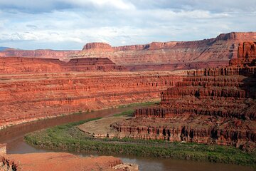
2. Mill Canyon Dinosaur Trail

Take an easy hike on the Mill Canyon Dinosaur Trail to see fossilized dinosaur bones—no park pass required.
By hiking along a river about 15 miles (24 kilometers) north of Moab, paleontology enthusiasts can travel back 150 million years to view Jurassic–age fossils at Mill Canyon Dinosaur Trail. Interpretive signs along the 1.8-mile (2.9-kilometer) trail point out petrified plants, dinosaur tracks, and bones, including fossil records that include prehistoric herbivores such as stegosaurus, camarasaurus, camptosaurus, and the meat-eating official state fossil of Utah, the mighty allosaurus.
While the fossils are impressive, there’s plenty more to see along the way, notably the ruined remains of the old copper mill the trail is named for, still visible on the south side of the canyon. Best of all, this off-the-beaten-path site is completely free to visit and often less crowded than many other sites near Moab.
3. The Windows Viewpoint

Embark on a short but impressively picturesque hike to the Windows Viewpoint in Arches National Park.
The Windows section of Arches National Park is densely packed with rock formations, many clustered around the 1-mile (1.6-kilometer) Windows Loop Trail that begins at the terminus of the Windows Road. Hiking the loop counterclockwise, look for the North Window to the left of the trail, then wrap past the South Window as you continue around the circle. There are countless ways to hike this one—before you reach the North Window, the Turret Arch Trail veers off to the right toward the freestanding Turret Arch.
Insider tip: From the same parking area, you can continue to the 0.6-mile (1.1-kilometer) Double Arch Trail that leads to the second-largest arch in the national park.
4. Corona Arch Trail

View three impressive arches from this moderate trail just outside the national parks’ boundaries.
As one of the best sites for viewing arches outside of Arches National Park, the 3-mile (4.8-kilometer) Corona Arch Trail sweeps over a captivating wall of mountains and red rock. Climbers will scramble up ladders and cables and rappel down rock walls to reach even better views (but if you’re not comfortable with heights, these exposed sections will be a challenge to navigate).
Along the way to Corona Arch, look for two other arches: Bowtie and Goldbar. At sunset, the entire area appears to glow, and the arch perfectly frames the landscape.
Insider tip: Pets are allowed on Corona Arch Trail—unlike the hiking trails in Arches National Park—and if you’re looking for where to stay in Moab close to impressive sights, this is one of the more conveniently located destinations near town.
5. Fisher Towers Trail

Trek to Fisher Towers to see soaring sandstone fins popular with rock climbers.
Don’t forget the camera on this 5.2-mile (8.4-kilometer) round-trip hike to Fisher Towers, where otherworldly rock formations include minarets, spires, and fins that rise from sloping cliffs. While the full, out-and-back hike is rewarding, you don’t have to go the full distance to soak up the impressive scenery. Many travelers opt for the 0.5-mile (0.6-kilometer) one-way trek to the Ancient Art rock formation, or the 1-mile (1.2-kilometer) walk to the base of Cottontail Tower.
Follow common sense hiking tips for Moab here, as shade is scarce—consider starting early on warm days, wear protective clothing, and bring plenty of water.
6. Mesa Arch Trail

Enjoy a short hike in Canyonlands National Park to catch amazing sunrise views at Mesa Arch Trail.
Photographers flock to the 0.6-mile (1-kilometer) Mesa Arch Trail in Canyonlands National Park at dawn, when the graceful rock formation frames views to the canyon and distant La Sal Mountains. While the loop hike is short, it isn’t easy. A rocky, uneven surface means this trail is off limits to wheelchair users—and sturdy footwear is a must.
Insider tip: If you tackle the loop hike in a counterclockwise direction, the walk begins with a fairly steep, uphill climb. To minimize elevation change, hike the clockwise direction to the arch, then retrace your steps back to the trailhead.
7. Gooseberry Trail

Challenge yourself to a longer hike on Gooseberry Trail, featuring steep slopes and switchbacks.
The steepest in Canyonlands National Park, the 4.6-mile (7.4-kilometer) Gooseberry Trail makes hikers work for their views—but the payoff is worth the effort. It starts in the park’s Island in the Sky region, where trails link the top of the mesa with the bench below.
Plan to spend 4–6 hours on the hike, which begins with a switchback descent from Mesa Top to White Rim Bench, crossing sheer cliffs and scree slopes (steep, unstable areas of small, loose rocks), backdropped by soaring vistas across the desert. Save plenty of time and energy for the return trip though, which takes you back up the switchbacks to the summit of the mesa. When you aren’t watching the landscape, watch your step.
8. Balanced Rock Trail

Balanced Rock Trail, a wheelchair-accessible hike, lights up at sunset.
While Balanced Rock in Arches National Park can be viewed from the road, the 0.3-mile (0.5-kilometer) loop hike around its base gives you an up-close perspective of the rock formation that’s topped with a bulging stone mass that appears to teeter on the slender tower.
The beginning of the hike is flat, paved, and wheelchair accessible, with views to the Windows and the La Sal Mountains. It’s especially spectacular at dusk, when sunset lends the rock a rose-red glow.
Insider tip: Toilets in Arches National Park are wheelchair accessible, and many viewpoints can be reached via smooth, paved surfaces.
9. Landscape Arch Trail

Check out Landscape Arch Trail, home to the longest arch in North America.
Arches, spires, and rock fins draw hikers to the Devils Garden section of Arches National Park. With an opening that spans an astonishing 306 feet (93.3 meters), Landscape Arch is the area’s most famous formation—and it’s accessible via the 1.8-mile (2.9-kilometer) Landscape Arch Trail that departs from the Devils Garden parking area. With an elevation change of just 40 feet (12 meters), it’s relatively flat, too.
Insider tip: The trail continues past Landscape Arch. The full Devils Garden Trail, which includes the Landscape Arch Trail, is 7.9 miles (12.7 kilometers) long and takes 3–5 hours to complete.
Book more things to do in Moab